By Oriz Anugerah Putra, Desti Ayunda (WRI Indonesia), Agiel Prakoso, Iola Abas
from Pantau Gambut
The Food Estate Project has officially entered its third year since its establishment in 2020. Back in 2020, The Food and Agriculture Organization (FAO) also issued a warning on the food crisis potential impact of quarantine policies and areal lockdowns to food supply chain disruptions on a global scale. Under the intention to maintain national food stocks demand, notably rice, Republic of Indonesia government put out discourse on paddy fields intensification and extensification through the Food Estate program. Shortly after the discourse was declared, this project was listed in Presidential Regulation Number 109/2020 concerning the National Strategic Project (PSN), validating the government's priority to actionize it.

Within its campaign, the Food Estate project reaps many pros and cons. The initial criticism from environmentalists and activists was that the location planned for the Food Estate development was an ex-peatland development (PLG). This area was previously utilized as a food granary but resulted in failure. Causing many questions to arise, why are peat areas still being used for Food Estate? Even though similar projects have failed and left severe damage to the ecosystem, resulting in huge losses for the country. Instead of repairing and restoring the condition of the land, this project was still constructed in the same area.

Some other criticisms and suggestions circulate around the problem of data transparency and the policy for farmers who will manage the Food Estate land. However, this project is still running.

From a regulatory standpoint, the Food Estate project also experienced many irregularities and was considered maladministration. The Food Estate project is not included in the 2020-2024 National Medium-Term Development Plan, hereinafter referred to as the National RPJM. The RPJMN document was signed in January 2020. Still, the Government Regulation (PP) regarding Food Estate was only formed in November 2020, after the project was already underway in several regions. Then the issuance of Minister of Environment and Forestry Regulation Number 24/2020 concerning Provision of Forest Areas for Food Estate Development which was later changed to Minister of Environment and Forestry Regulation Number 7/2021 concerning Forestry Planning, Changes in Allocation of Forest Areas and Changes in Functions of Forest Areas, as well as Potential Use of Forest Areas contradicts Law Number 41/1999 on forestry.

The most controversial and widely discussed issue in the Minister of Environment and Forestry Regulation Number 24/2021 is the threat of utilizing protected areas for Food Estate projects. Based on the Regulation of the Minister of Environment and Forestry Number 7/2021, article 485 states that "protected forest areas which are completely no longer functioning as a provision can be used for Food Estate activities" has become a topic of discussion and debate by a number of observers because it contradicts the definition of protected areas according to Forestry Law. Matters arise as to why the Government doesn't engage in restoring protected areas that no longer function as protection. Contradictory, the site is utilized for Food Estate project activities instead.

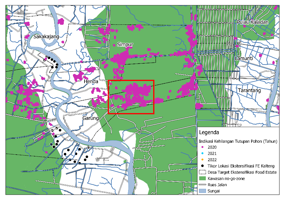
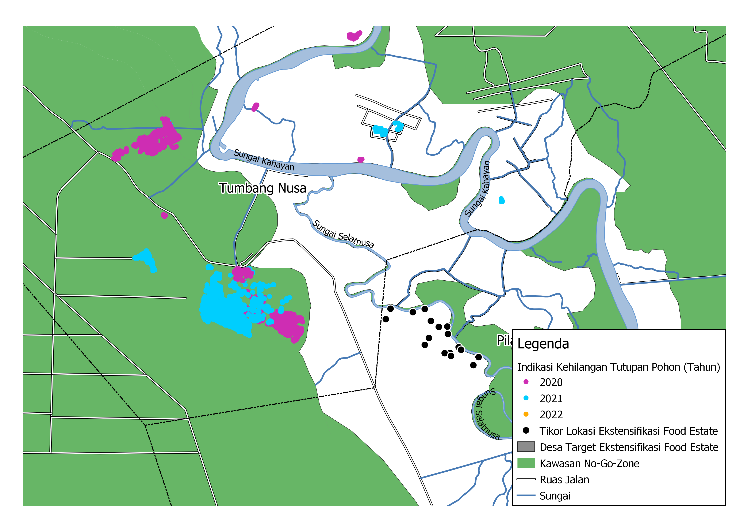
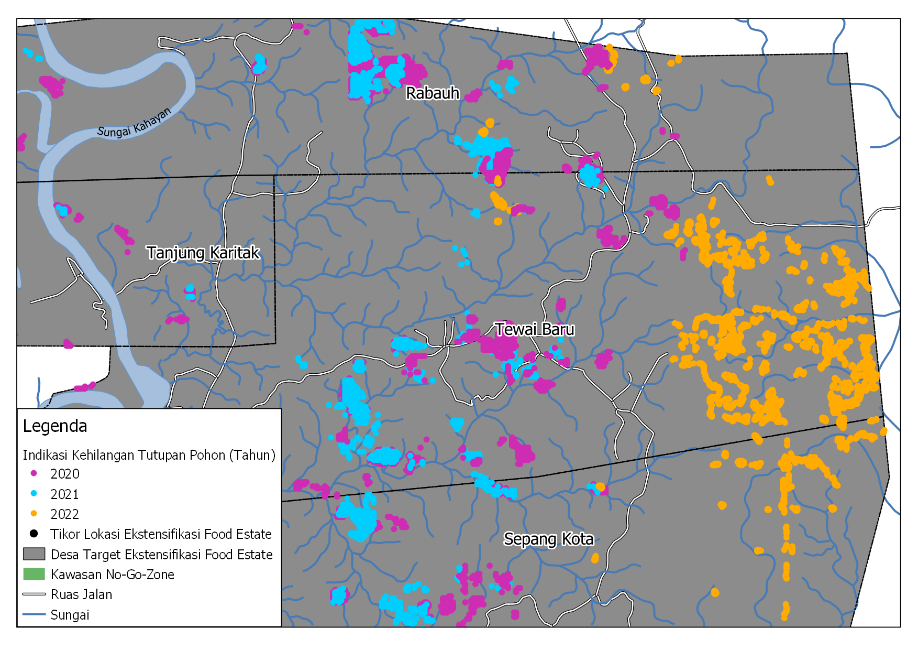
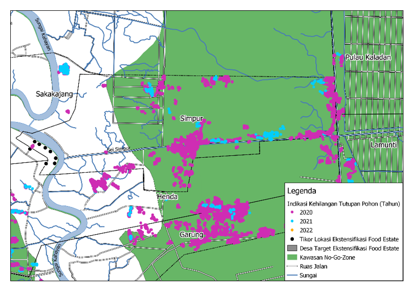
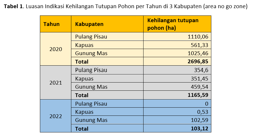
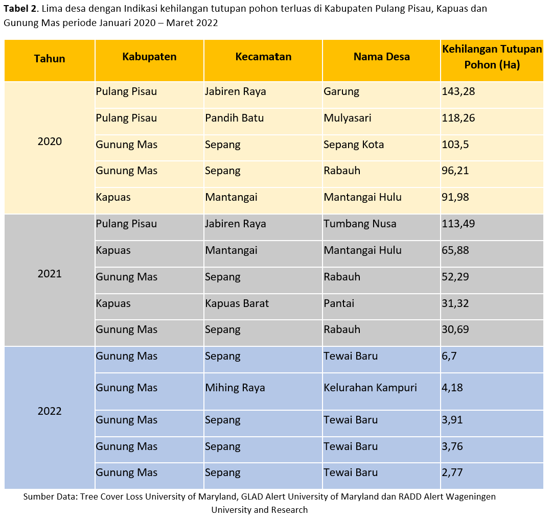
Indication of Tree Cover Loss in 3 Regencies (Pulang Pisau, Kapuas and Gunung Mas)

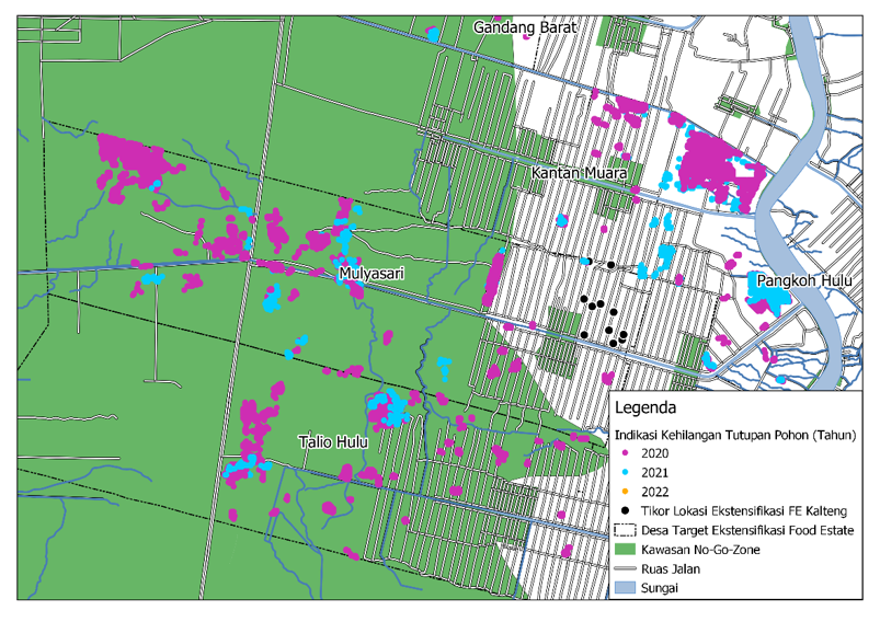
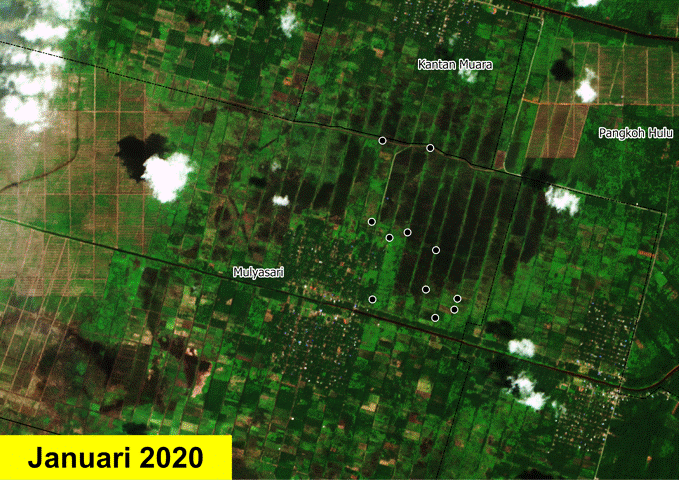
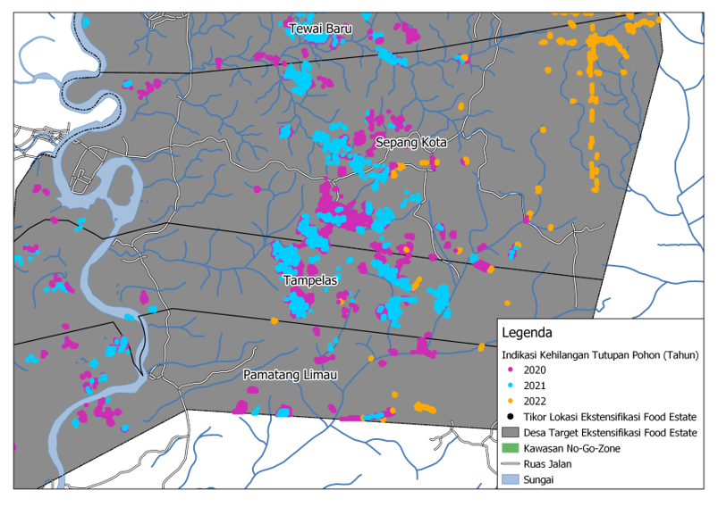
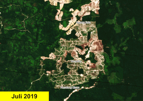
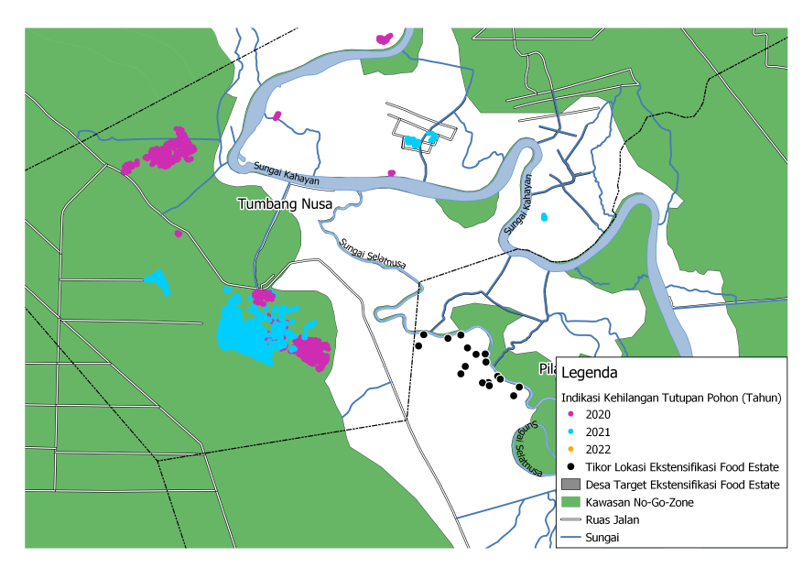
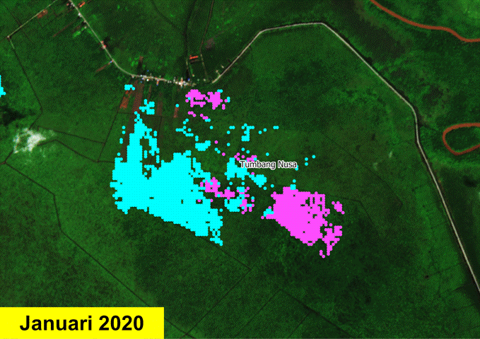
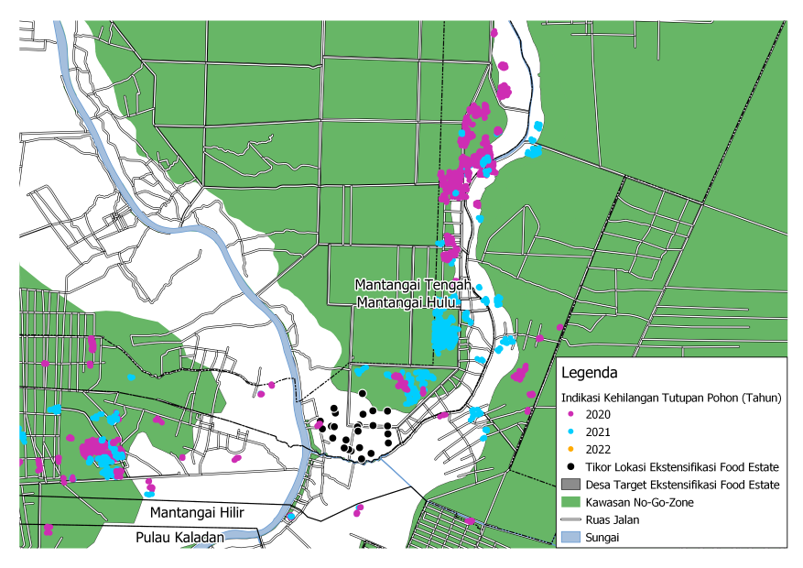
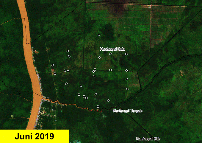
To see indications of threats to protected areas, Pantau Gambut tries to analyze data indicating tree cover loss from 2020-2022 in 3 regencies in Central Kalimantan, namely Pulang Pisau, Kapuas, and Gunung Mas. These regencies are included in the initial development area of the Food Estate project.

Regarding Pulang Pisau and Kapuas regencies, Pantau Gambut overlaps the area indicating tree cover loss with the No-Go Zone map. The map indicates areas with high conservation value that need to be protected and abstained from the development of a Food Estate project. The map analyzed three criteria:

  1. Peatlands with a depth of > 1 meter
  2. Peatlands with primary and secondary forest vegetation
  3. Peatlands with a protective function

The results were foreseeable, there were indications of tree cover loss during the 2020-2022 period in several villages in the three regencies, some of which even reached an area of more than 100 hectares or the equivalent of 125 times the size of a football field. In Pulang Pisau and Kapuas regencies, exist indications of tree cover loss that sheathe the no-go zone map. Signifying The Food Estate project occurred in the expectedly protected area. 

Furthermore, Pantau Gambut collected data on the five villages with the largest area of tree cover loss each year in the three regencies.

The data in table 2 indicates the tree cover loss with the largest area that occurred in 2020, prevailed over Pulang Pisau and Gunung Mas regencies, reaching 717.84 ha. The most shrinkage is located in Garung Village, Pulang Pisau regencies, with an estimated area of 143.28 ha. As shown in Figure 1, the area detected by the imagery (purple dot) is in the no-go zone map (green), which is obliged to be protected and abstained from developing a Food Estate project. 

In 2021, there are still indications of tree cover loss in 3 regencies but not as significant as in 2020, around 293.67 hectares. The case-in-point area happens in Tumbang Nusa Village, Pulang Pisau regencies with 113.49 hectares loss. Similar to Garung Village, the results of identification in Tumbang Nusa Village are also encompassed in the no-go zone map.

In 2022, the indications of tree cover loss in the three regencies were hypothetically smaller. Because the used data is at most January-March, analysis with the rest of 2022 data is needed to comprehend the total indications of tree cover loss in 2022. The largest land clearing in 2020 was in Gunung Mas District in the village of Tewai Baru. The results of the spatial visualization of tree cover loss in Tewai Baru Village are shown in Figure 3, with an estimated area of 17.14 ha spread across several points.

Satellite Image Verification of Tree Cover Loss Data in Pulang Pisau, Kapuas and Gunung Mas Regencies

From the data exhibiting tree cover loss, Pantau Gambut conducted further verification through satellite imagery to configure changes in land cover from these locations. Consequently, there have been changes in several locations' landscapes, indicating a tree cover loss. Although some of them show "false positive" results. The verification of satellite imagery is divided into two categories:

1. No indication of land clearing (false positive)

In this category, the results of satellite imagery visualization do not show any indications of changes in the landscape and land clearing. If the imagery is correct, two things can happen:

a. Loss of tree cover occurred due to fires prior to the Food Estate project discourse

Based on the results of satellite imagery visualization, the loss of tree cover in Garung village is thought to have been caused by a major fire in September 2019, originally green land that had turned scorched brown. The fire occurred before there was a discourse about developing a Food Estate project, so it is suspected that the fire that ensued was not due to the opening of new land for the Food Estate project.

b. The observed area is plantation/agricultural land, the land clearing occurs due to harvesting.

In this context, from the results of satellite imagery verification, the indicated area of tree cover loss was an area designated for community plantations/agriculture, so it was alleged to be a harvesting activity. As can be seen in Figure 5, the observed area is indeed a plantation area marked by a structured irrigation visualization. The harvesting activity that was carried out turned the area that was originally green in color to brown so that the tree cover indication data indicates tree cover loss.

2. Visible indications of land clearing in forest/densely vegetated areas

In this case, observations from tree cover loss data which are then verified through satellite imagery, show indications of land clearing in densely vegetated areas.

From the results of image verification, in the four years (2019-2022), there has been a change in the landscape at the observed location. It can be seen that the land that was previously covered with vegetation in 2019 is starting to be cleared, which is marked by green areas that turn brown in a structured and massive manner.

In Figure 6, a massive tree cover was lost in Sepang Kota Village, Gunung Mas District. This land clearing has occurred since 2019 and will continue until 2022. 

Even though the intention of the land opening is currently unknown, the clearance area depicted by satellite imagery appears very damaging and endangers the existing peat ecosystem.

In figure 7, the tree cover loss in Tumbang Nusa Village is strikingly visible, the land clearing is for rice fields. It is conspicuous from the beginning of 2020 the condition of the land is still vegetated marked in green. Then the land was cleared and turned into a rice field area by the end of 2020.

The land clearing in Tumbang Nusa Village also entered the no-go zone (green) map, which should not be used or cultivated for Food Estate activities. 

Verification of satellite imagery regarding the coordinates of the rice field extension

Apart from identifying data on tree cover loss, Pantau Gambut also conducted a satellite image analysis of the location of the rice Food Estate development to see changes in the landscape that have occurred in the area. Data on the coordinates of the location of the rice Food Estate extension was obtained through a survey report document from the University of Palangkaraya team.

Correspondingly, many densely vegetated areas then turned into rice fields. It can be seen from satellite imagery that previously described the appearance of a green area in 2019, which then turned brown and is structured like a rice field area from 2021 to 2022 (Figures 8 and 9). Even though many coordinate points for rice field extension are not included in the no-go zone (green) area, further studies by the government and academics are needed as well as supervision in its implementation. As a form of monitoring and evaluation so that land management in the area does not damage the peat ecosystem.

From the results of this analysis, further studies and field verification are needed to find out and ascertain the activities taking place in the field, especially in areas where there is an indication of tree cover loss, whether there is deforestation for the development of this Food Estate project. The implementation of the Food Estate project must continue to be monitored so that it does not damage the peat ecosystem and environmental sustainability around it because it is the community that will bear and feel the impact of activities that damage the peat ecosystem and the environment.

Support Us

Share this information with your family and friends.