Food Estate: Reopening the Peatland due to the Pandemic
By Dimas N. HartonoMystery of the Extent of Burned Peatland in Lukun, Riau
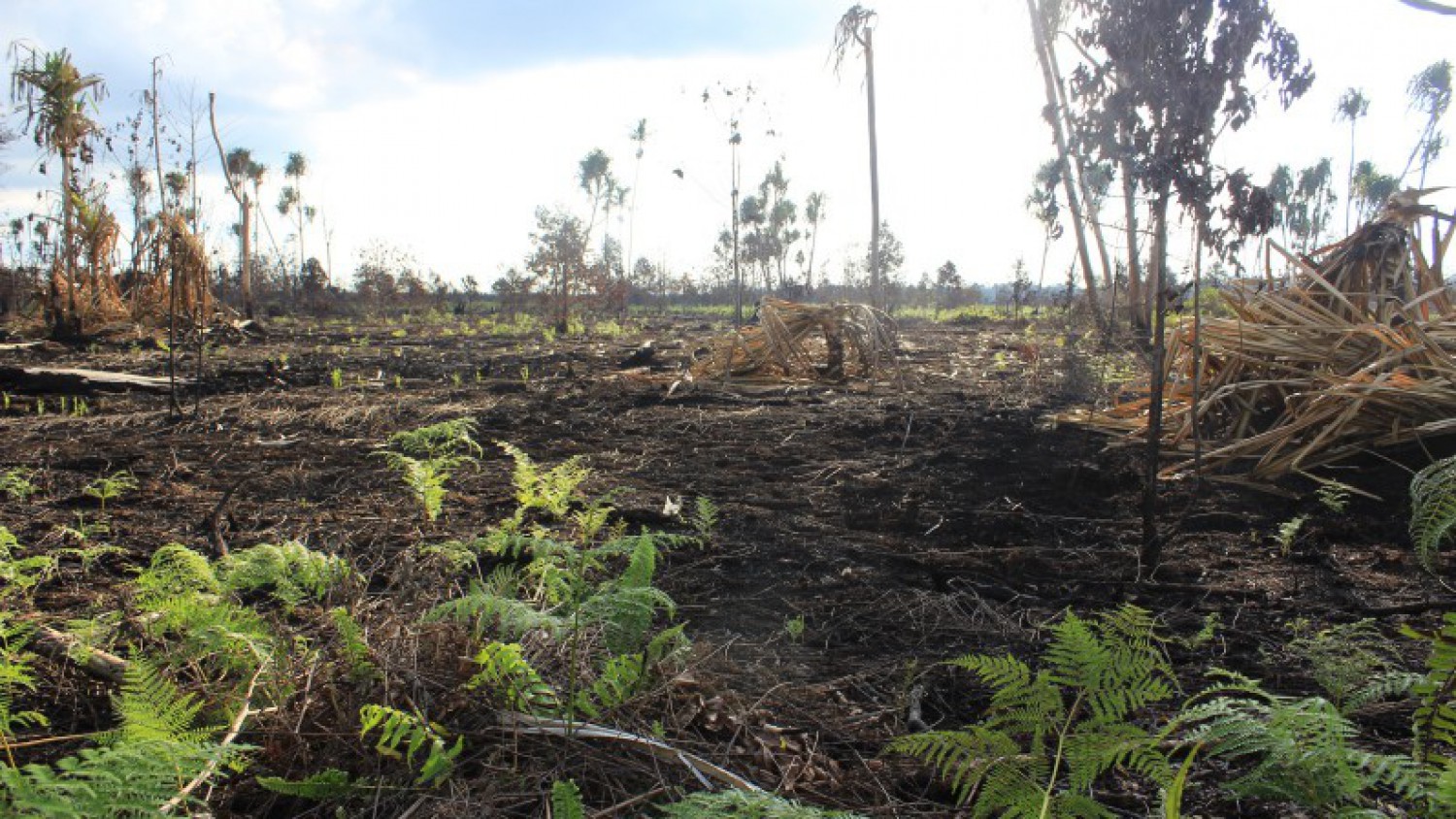
Fire reoccurred on the peatland of Lukun Village, Tebing Tinggi Timur Subdistrict, Meranti Islands District, Riau in February 2019, repeating the fire at the beginning of 2018. The fire was just brought under control after almost two months because fire spread easily on peatland and the location was hard to reach.
Earlier this year, forest and peatland fires occurred in some areas in Riau. Pantau Gambut’s analysis on the number of hotspots in Riau in January-March 2019 even showed an increasing trend compared to the same period in 2015. In February 2019, the VIIRS sensor detected 94 hotspots, which was higher than the 74 hotspots detected in February 2015.
Peatland in Lukun Village was one of the areas burned during this period. Interestingly, the same area was also burned in the 2014 and 2018 fires. Some areas of dense forest were also burned.
In the second week of March 2019 or almost a month since the fire was first noticed, smoke still rises in several spots in the forest. According to Amran, Head of the Lukun Village Forest Management Agency, if the fire is not immediately extinguished, it can quickly spread to deeper parts of the forest that have never been burned.
"This area has never been burned. The trees are still big and solid. We must save them,” said Amran.
He said that the fire was initially spotted on the night of 10 February 2019. After confirming the location of the fire, Amran together with Lukman, head of Lukun Village, and the residents immediately went there. They brought simple firefighting equipment and arrived at the location at midnight. The fire raged fiercely in the area that had been burned before.
Several parties participated in the firefighting, including the village head, Manggala Agni, as well as members of the national police and the military. However, the team from Lukun Village Forest Management Agency stayed the longest to extinguish the fire. They stayed almost two full months near the fire site, which was quite far from the village.
According to a report from the Riau Regional Disaster Management Agency (BPBD), 232.4 hectares were burned in Meranti Islands District as of the end of March 2019. The burned peatlands and forest spread over several villages in the district, including Lukun Village. There is a big difference between the data from Riau BPBD and the data from the field. The Village Forest Management Agency reported that 400 hectares were burned in Lukun Village in the same period.
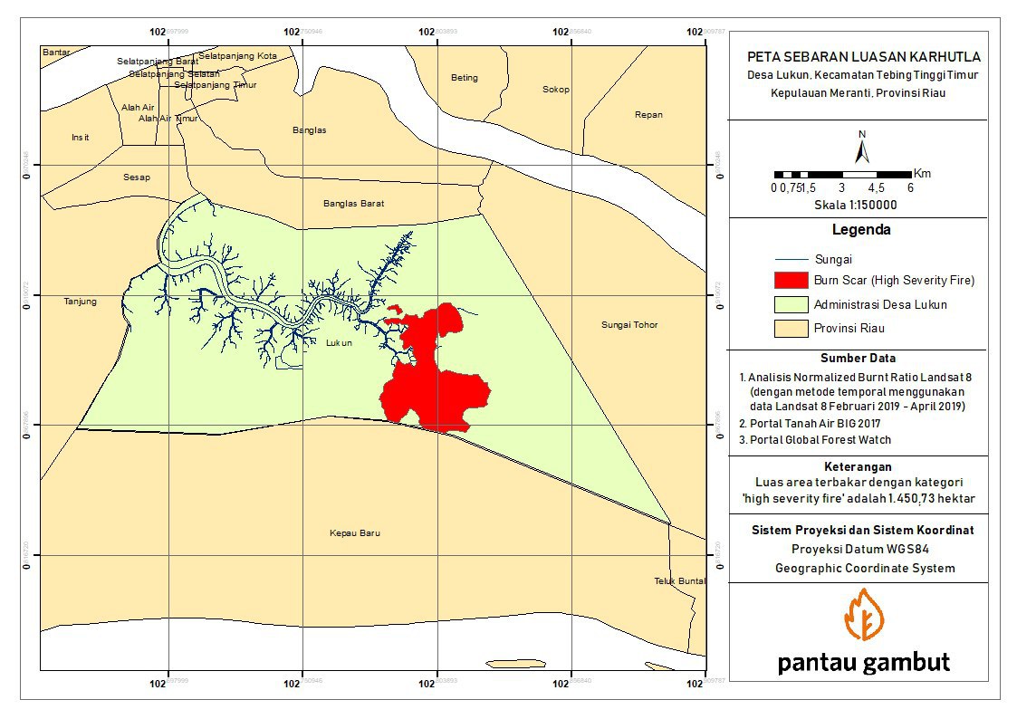
To confirm the extent of the fire in Lukun, Pantau Gambut conducted a spatial analysis of the burned area in this village. They used the normalized burn ratio and Landsat data downloaded for the period of 8 February 2019 to 30 April 2019.
The analysis result showed that 1,450.73 hectares were burned in Lukun in the period 8 February 2019 to 30 April 2019. The area showed by this spatial analysis is the burned area that was observed from February to March.
Based on data from the VIIRS NASA sensor, 20 hotspots with high confidence level were observed from February to March 2019. In April 2019, no hotspots with high confidence level were detected by the sensor. Thus, the burned area on the map is the result of fires that occurred from February to March.
This was not the first time that data discrepancies were found regarding the extent of fires in Lukun. In early 2018, the peatland in this village got burned. Riau BPBD said that 731.5 hectares of forests and lands were burned from early January to 26 February 2018 in Riau Province, including the 200 hectares that were burned in Lukun Village. However, researchers from the University of Riau had very different data. The research, which was facilitated by the Peatland Restoration Agency (BRG), revealed that 1,224 hectares were burned in Lukun alone.
Lukun is one of the villages whose area is targeted in the restoration program for 2 million hectares of peatlands. Since 2017, BRG has implemented several restoration programs, especially the construction of peat rewetting infrastructure in the form of canal blocks to maintain the soil’s level of wetness so that it won’t be easily burned. Apart from rewetting, there are also community economic revitalization and research programs. The peat restoration program in Lukun involves the community through the collaboration between BRG and the Center for Disaster Studies at the University of Riau in 2017 and with Damai Community Group in 2018.
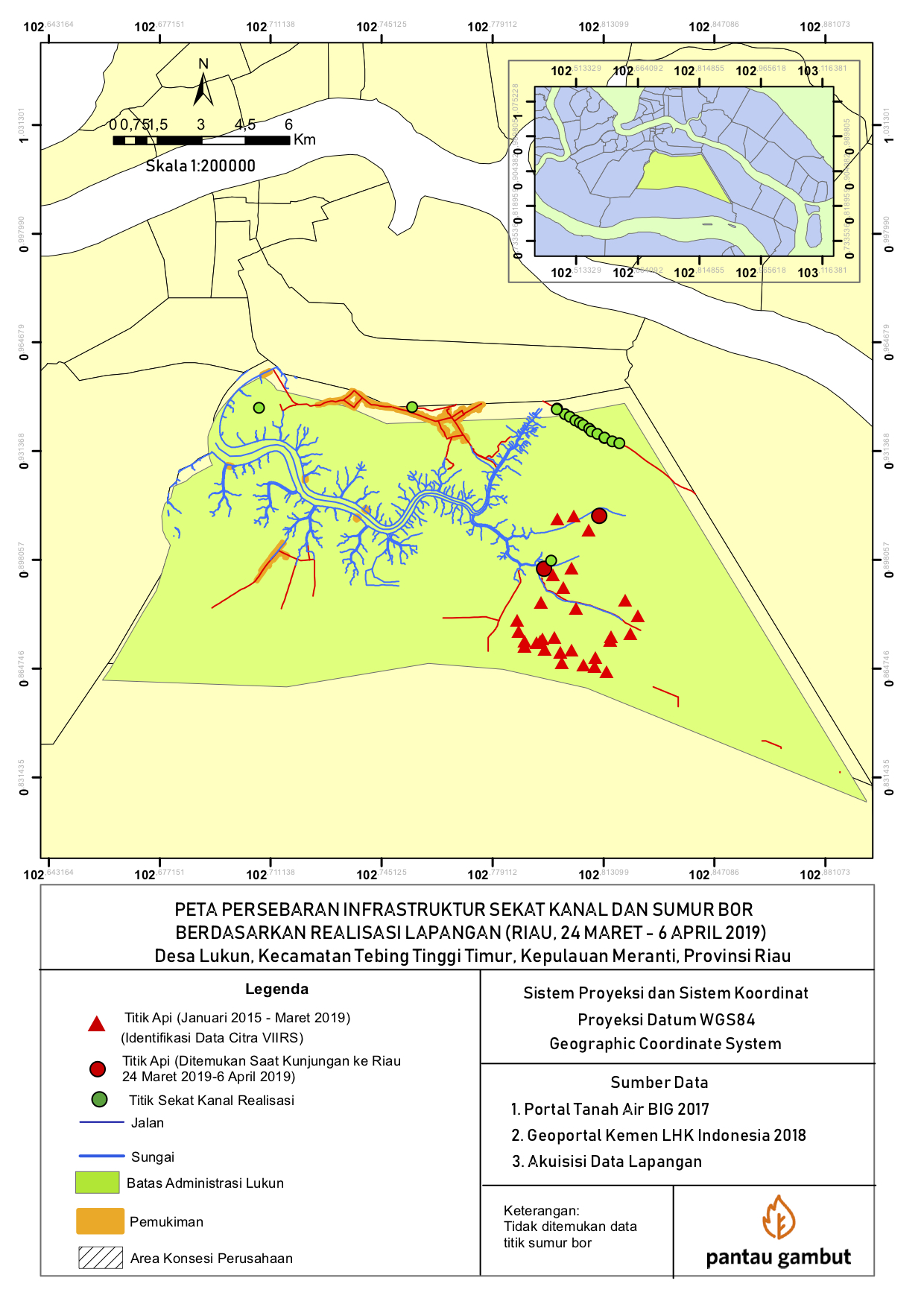
Field observation confirmed that several canal blocks are already working. The Simpul Jaringan Pantau Gambut team visited Lukun and saw 17 canal blocks in this village. 16 canal blocks were located on the right and left sides of the village main road and close to the residential areas. The distance from one canal block to another was about 150 to 300 meters. From the project signpost, we could see that the canal blocks were built in 2017.
The other canal block was located quite far from the residential areas and was easier to reach by water transportation. The location of the peatland fire in early 2019 was near that canal block (see map).
The map shows that most of the canal blocks are located in areas that are not prone to fire or without hotspots. Therefore, some residents thought that the wetting infrastructure construction program in Lukun was not well targeted, so that fires continued to recur in locations that could have been anticipated.
BRG's Deputy for Education, Dissemination, Participation, and Partnership, Myrna A Safitri, admitted that the canal blocks were far from the usual fire spots. However, the construction sites were selected based on the residents' suggestions.
"We have checked that the fire location was quite far from the residential areas. We prioritized the construction of canal blocks near the residents' settlements based on their proposal. We have gone through the Free, Prior, and Informed Consent process,” Myrna said.
This was confirmed by the Head of Lukun Village, Lukman. He said that the construction of canal blocks near the settlements was also important because this location almost caught fire in 2014. Moreover, they also considered the cost. The budget wouldn’t be sufficient if they built canal blocks in the forest that can only be reached on foot 3 kilometers away from the settlements.
“If we were to build the canal blocks at the location of the fire, it would be too far. We would need extra costs for transporting the building materials,” said Lukman. However, the residents hope that the next program can be implemented in those burned locations.
