By Donny Muslim
from Pantau Gambut

The prevalence of conversion and poor management of peatlands increases the complexity of floods in the downstream area of ​​South Kalimantan. The water-absorbing function of peat is not optimized. As opposed to being safe from disasters, a number of villages in this area were submerged.

Limamar Village, Astambul Sub-District, Banjar District was one of the villages that experienced flooding in South Kalimantan in early 2021. The peat in this village has begun to suffer damage due to the high number of land conversions. Areas with high-quality peat supposedly will not experience flooding or drought, because peat functions like a sponge by absorbing and storing a large volume of water. Therefore, there will be no drought or vice versa during the dry season and there will be no flooding during the rainy season.

"This was the worst flood. In the past, there was a flood in 2006 but the water level only reached our knees," said Rahmat Mulyadi, a resident of Limamar Village.

Rahmat said that the flood started on Saturday (16/1/2021). He said that the water came from upstream areas, namely Pengaron Sub-District, Banjar District, which had already experienced flooding.

The first day was not concerning, however, the floods did not subside day after day. In addition, the rain continued to pour in South Kalimantan. The flood peaked on Thursday (21/1/2021) and the water level has even reached waist height.

"At that point, residents started to be evacuated. Some chose to stay in the village because they were securing their belongings," Rahmat said to Pantau Gambut recently.

Approximately 800 people were affected in Limamar Village and surrounding areas. When they left the village, they scattered to find a place of refuge.

Rahmat admitted that the changes in the peat landscape around Limamar and its surrounding areas became a problem during floods.

The South Kalimantan Environment Agency data indicates that approximately 60% of the peatlands in this area were damaged due to land conversion and drought.

Based on data from the Indonesian Forum for the Environment (WALHI-South Kalimantan), 31.75% of the total area of Bumi Lambung Mangkurat holds mineral and coal mining permits, 14.42% is industrial forest plantations (HTI), 10.15% holds right to cultivate (HGU) and 5.36% is a natural forest area (HA).

Loss of peat ecosystem function

Previously a peatland area, the Limamar village to the border of Banjar District and Barito Kuala District is now rife with large-scale monoculture plantations, including settlements. As a result, the water-absorbing function of peat has begun to decrease, hence the drainage process becomes slow.

"Peat naturally functions like a sponge (it can absorb water). It acts as a reservoir and can serve as a water channel," said Rahmat, who is also an environmental activist in Limamar Village.

Changes in the peat ecosystem have also affected other locations, such as Hapalah Village, Benua Lawas Sub-District, Tabalong District. The flood in the area submerged dozens of houses and the water level was knee-deep. In fact, according to Mistani, the local village leader, the flood should not have occurred because their village is surrounded by swamps and peatlands.

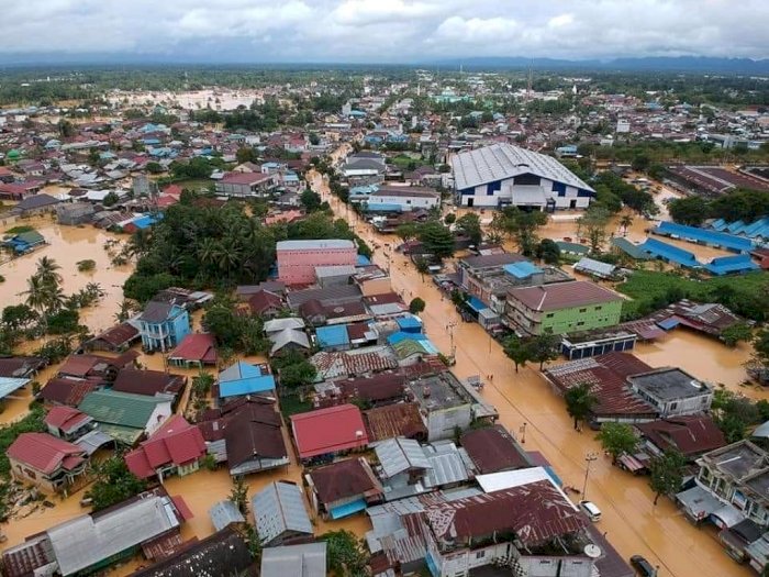
"The flooding was worst on 12 – 16 January 2021. More than five houses were submerged, the roads were also flooded. All the seeds (rice) were also submerged," said Imis, his nickname.

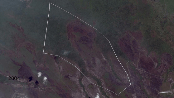
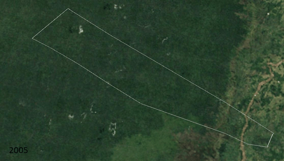
Imis suspects that the construction of canals on peatlands by oil palm companies in the Hapalah Village in 2010 disrupted the surrounding ecosystem.

"At that time, no permit was issued, but canals have been built. Since then, our village has been routinely flooded," said Imis.

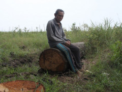
In addition to frequent flooding, Imis added that almost all peat swamp agricultural lands could no longer be cultivated for the last ten years or so because they are often submerged. Residents now survive with some land that can still be used for farming, while some choose to leave the village to improve their livelihood.

Signals of Ecosystem Disruption

The stories that Rahmat and Imis shared are just two of the many experiences of residents about peatlands affected by floods.

In order to prevent similar incidents from reoccurring, Bambang Hero Saharjo, Professor of the Bogor Agricultural University (IPB), encouraged the local government to be more serious in carrying out disaster mitigation efforts related to the destruction of ecosystems.

"When we talk about flooding, I think it's a signal. It's a signal of ecosystem disruption that has not been restored," said Bambang when contacted by Pantau Gambut via cell phone.

Because South Kalimantan is surrounded by peat swamps, Bambang asked the local government to maximize its verification efforts, to identify which peatlands are protected and which are not.

"For example, no canals can be built in protected peat areas. On the other hand, peatland cultivation areas must be properly managed. For example, by building canal blockings," said Bambang.

He also reminded that referring to Government Regulation no. 57 of 2016 concerning the Protection and Management of Peat Ecosystems, peatlands with a depth of more than three meters should be conserved.

Support Us

Share this information with your family and friends.