
| PG Study
The Winding Road to Peatland Restoration
By Admin Pantau GambutAfter the forest and land fires in 2015, the Indonesian government rolled out a number of policies to prevent the recurrence of a disaster which devastated 2.6 million hectares of land and claimed many lives. One of the policies enforced is the restoration of 2.49 million hectares of peatland. This policy was put in place because half of 2.6 million hectares of land burned in 2015 was peatland. For highly flammable peatlands, either due to natural or human factors, interventions are considered the best way to prevent recurrence of forest and land fires.
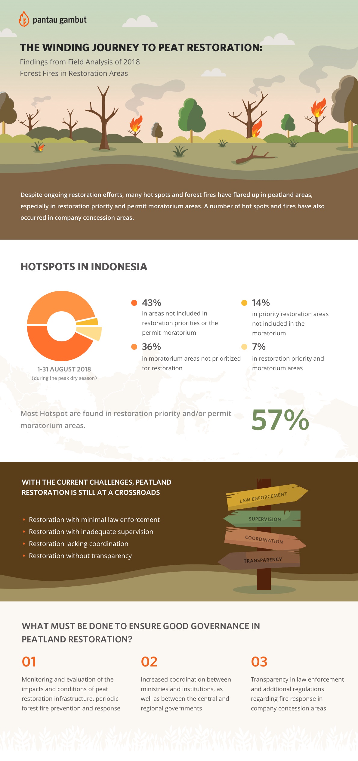
Pantau Gambut conducted an analysis of the spatial data of hotspots that were monitored through NASA's VIIRS sensor from August 1-31, 2018. As an analysis, the data was compared with data on peatland restoration priority areas from BRG in 7 provinces and an indicative map of the postponement of new permits (PIPPIB ) XII Revision. In this analysis, Pantau Gambut categorized these hot spots into 4 area categories, namely:
From the results of the sensor data overlay, the restoration map, as well as PIPPIB XII, Pantau Gambut found that most of the hotspots were in the priority areas of peatland restoration and the moratorium area for peat utilization. On the other hand, hot spots were not be found again in areas where restoration activities have been carried out.
Additionally, Pantau Gambut's Simpul Jaringan in 7 priority restoration provinces also found hot spots occurring within the concession areas of plantation and forestry companies. Without prejudice to climate factors, Pantau Gambut sees that the presence of hot spots in the company's permit area shows the importance of encouraging the implementation of restoration involving the private sector. From the targeted 2.46 million hectare restoration of peatland in 2020, 1.4 million hectares is company concession area.
In addition to spatial data analysis and maps, Pantau Gambut's Simpul Jaringan also conducts direct investigations into the field to investigate the causes of forest and land fires at hot spots. The direct monitoring target is knowing, among other things, the implementation of restoration and law enforcement programs for those who violate the law and start the fires.
In this study, Pantau Gambut offers recommendations as a solution to overcome problems in prevention and handling of forest and land fires, especially in priority areas of restoration as well as within the company concession area. Pantau Gambut hopes that the recommendations given can bring the restoration and protection of the peatland ecosystem to a better shape, aligned, and in line with the pledges made by the government.


